Update on Typhoon Yagiri Route: Meteorological Department’s Latest Announcement
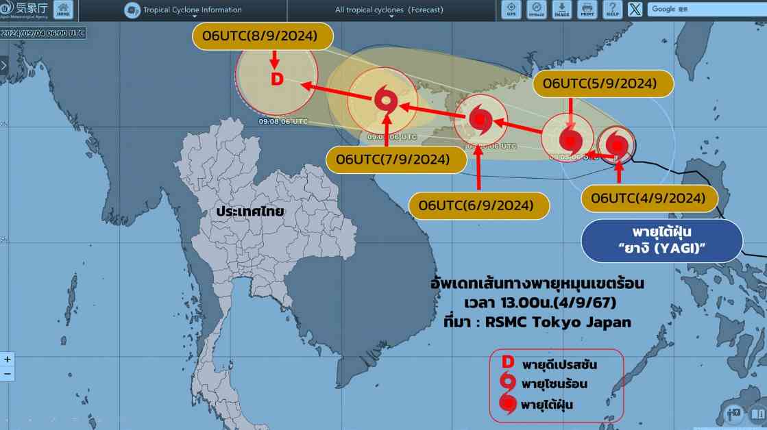
The Meteorological Department has recently released the 5th edition of updates regarding Typhoon Yagiri, providing crucial information on the storm’s current location and projected path. As of 4th September 2567, at 5:00 PM, the typhoon was situated in the upper part of the South China Sea, with its center located at approximately 19.2 degrees north latitude and 117.2 degrees east longitude. The storm is moving slowly towards the northwest, with maximum wind speeds near the center reaching around 150 kilometers per hour.
Forecast and Impact on Surrounding Areas
It is predicted that Typhoon Yagiri will continue on its current trajectory, passing through the Paracel Islands, China, and making landfall along the northern coast of Vietnam on 6th to 7th September 2567. Following this, the typhoon is expected to weaken gradually. This weather pattern will result in heavy rainfall and strong winds in the northern and northeastern parts of Vietnam, causing potential disruptions and hazards in these regions.
Moreover, from 4th to 6th September 2567, the southwestern monsoon prevailing over the southern part of the South China Sea and the Gulf of Thailand is significantly strong, creating rough seas and adverse weather conditions. Consequently, Thailand is likely to experience heavy rainfall, particularly in the eastern and southern coastal areas. The sea conditions in the Andaman Sea and the upper Gulf of Thailand are expected to be quite intense, with waves reaching heights of 2-3 meters. Areas experiencing thunderstorms may encounter even higher wave heights exceeding 3 meters, posing risks to maritime activities.
It is advised that all maritime operators exercise caution and avoid sailing in areas with thunderstorms. Small boats in the South China Sea and the upper Gulf of Thailand should remain docked until 8th September 2567 to ensure safety. The Meteorological Department continues to monitor the situation closely and urges the public to stay informed about any updates regarding the storm.
Evolution of Typhoon Yagiri: Current Status and Future Projections
As of 4th September 2567, at 1:00 PM, Typhoon Yagiri has intensified into a tropical cyclone, gaining strength as it moves westward, slightly veering towards the north. The storm’s path is expected to traverse through the Lao Islands, Gulf of Tonkin, and make landfall in the northern part of Vietnam on 7th to 8th September 2567. Subsequently, it will weaken further as it progresses towards the southern part of Laos.
While the typhoon has not yet entered Thai territory, its influence has contributed to the persistence of the prevailing southwestern monsoon, maintaining strong winds and heavy rain over the country. The fluctuating trajectory of the storm may result in increased cloud cover and rainfall in the northern and northeastern regions of Thailand from 8th to 10th September 2567. Additionally, the combination of monsoonal effects and low-pressure systems could lead to atmospheric instability, impacting weather conditions across the affected areas.
In conclusion, the evolving nature of Typhoon Yagiri demands continuous monitoring and preparedness from relevant authorities and the public. By staying vigilant and adhering to safety guidelines, individuals can mitigate potential risks and ensure their well-being during adverse weather events. The Meteorological Department remains committed to providing timely updates and guidance to safeguard communities from the impacts of natural disasters.


