Thailand News: Four Potential Routes for the Koh Chang Bridge Development
The Expressway Authority of Thailand (EXAT) has recently kicked off a series of public hearings to discuss the construction of a bridge that would connect the mainland to Koh Chang Island, a beloved destination in Trat province. The first of these hearings took place on September 2 in Mueang district and received overwhelming support from local residents and business owners.
The attendees at the hearing expressed a strong preference for the bridge to pass through the Mueang district, citing the potential economic benefits that this route could bring to the area. This district is considered a business hub in eastern Thailand, and participants believe that guiding travelers through this area would foster increased commerce and tourism.
Two of the proposed routes align with the community’s request and aim to enhance economic growth in Trat province. Attendees also advocated for a lower bridge toll compared to current ferry fares, the inclusion of lanes for motorcycles and bicycles, and the incorporation of scenic viewpoints at both ends of the bridge. EXAT representatives acknowledged these suggestions and confirmed that the bridge’s design would prioritize economic development for Koh Chang and its surrounding areas.
Deputy Governor Katpachon Udomthampakdee emphasized that the bridge would improve accessibility for both visitors and residents of Koh Chang, making it easier to access essential services such as schools and hospitals on the mainland. Trat Governor Nathapong Sa-nguanchit reassured the public that local stakeholders are fully supportive of the bridge project.
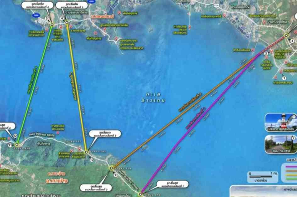
There are four proposed routes for the bridge, each involving different starting points on the mainland and the island. The first route is set to begin at the 0.85-kilometer marker on Highway 3156 in Ban Nong Prue village, Laem Ngop district. This 9.82-kilometer route would connect to the island at the 8.55-kilometer marker on Road 10026 in Ban Dan Mai.
The second route, also starting at the 0.85-kilometer marker on Highway 3156, spans 9.95 kilometers and would land at the 6.75-kilometer marker on Road 10026 in Ban Dan Mai. The third proposed route is slated to start at the 2.84-kilometer marker on Road 4006 in Ban Thammachat Lang, Laem Ngop district. This 5.90-kilometer route would reach the island at the 5.30-kilometer marker on Road 10026 in Ban Dan Mai.
The final route is proposed to begin at the 3.50-kilometer marker on Road 4006 in Ban Thammachat Lang, with a 5.59-kilometer span that would end at the 1.90-kilometer marker on Road 10026 in Ban Khlong Son. All four routes are planned to be elevated to ensure sufficient clearance for maritime traffic, and construction will be carried out with the goal of minimizing environmental impact on the coral and seagrass around Koh Chang.
According to a report by Bangkok Post, construction on the Koh Chang Bridge is scheduled to begin in 2029, with the bridge expected to open in 2033. This timeline allows for careful planning and execution of the project to ensure its success and sustainability.
In Conclusion
The proposed Koh Chang Bridge project has garnered significant support from the local community and stakeholders, who see it as a vital infrastructure development that could boost economic growth in Trat province. With four potential routes under consideration, the bridge aims to provide better accessibility for both visitors and residents of Koh Chang while minimizing environmental impact on the island’s delicate marine ecosystems.
As construction on the bridge is set to commence in 2029, the project represents a significant step towards enhancing connectivity and promoting sustainable development in the region. With careful planning and execution, the Koh Chang Bridge has the potential to become a key landmark that benefits the local economy and tourism industry for years to come.


